.jpg)
Land & Sea Surveying Concepts, INC.
1605 CHASE HAMMOCK RD.
MERRITT ISLAND, FLORIDA 32953PHONE: 321.454.6310 FAX: 321.454.6998
.jpg)
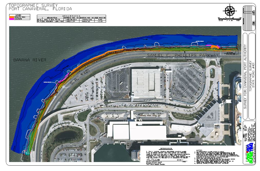
March 2018: Port Canaveral, FL.
Land & Sea Surveying performed a full topographic survey of the shoreline adjacent to State Road 401 and Cruise Terminal 10 upland at Port Canaveral.
.JPG)
.jpg)
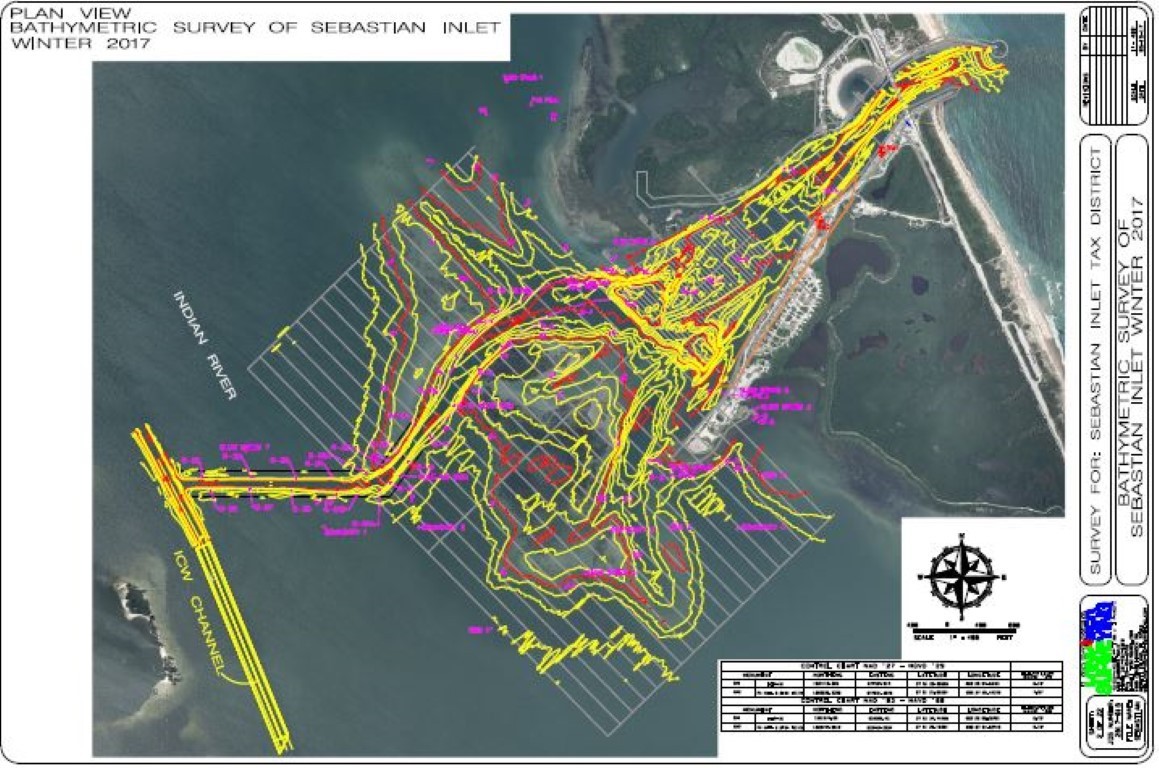
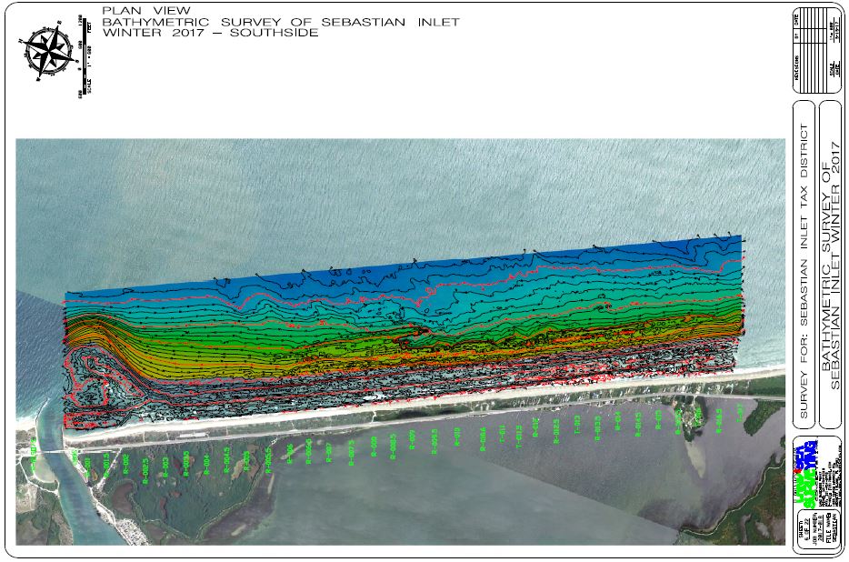
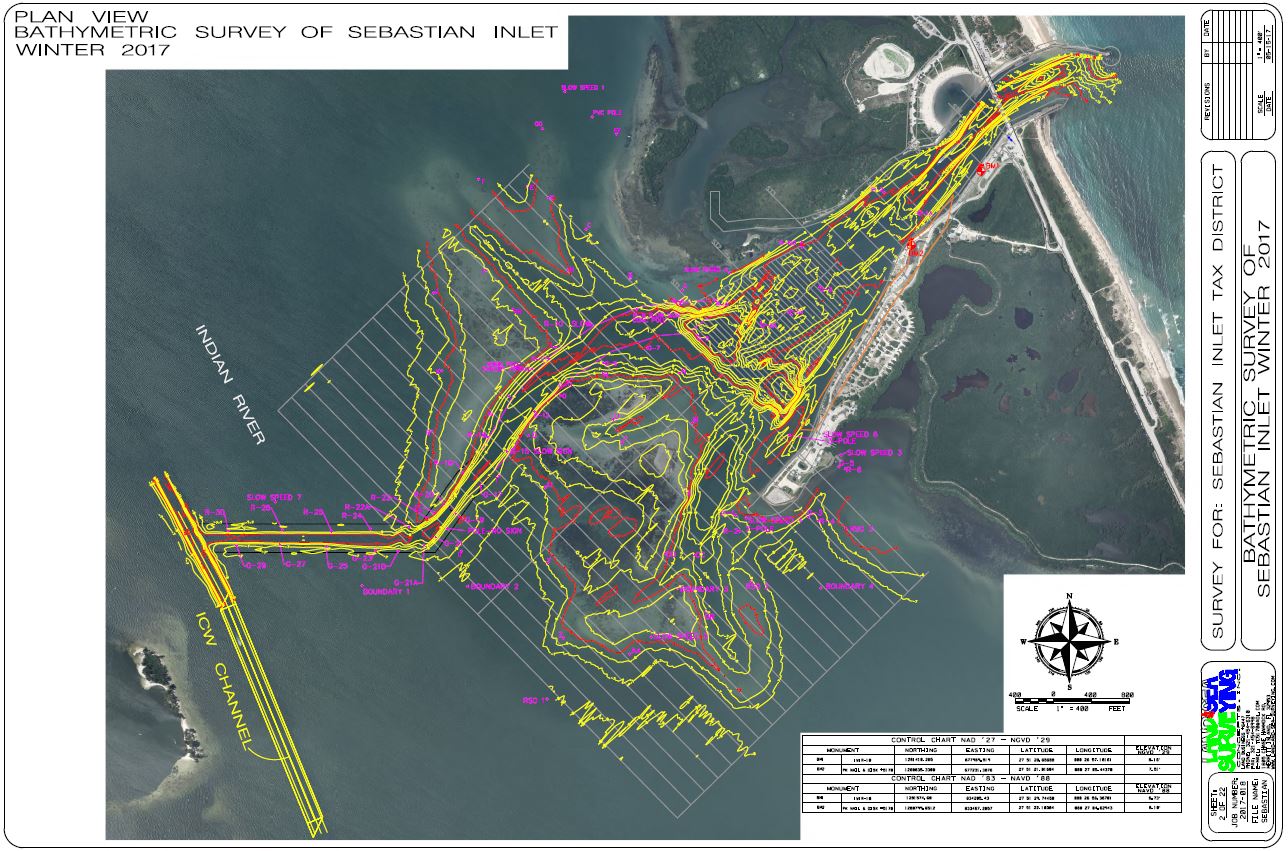
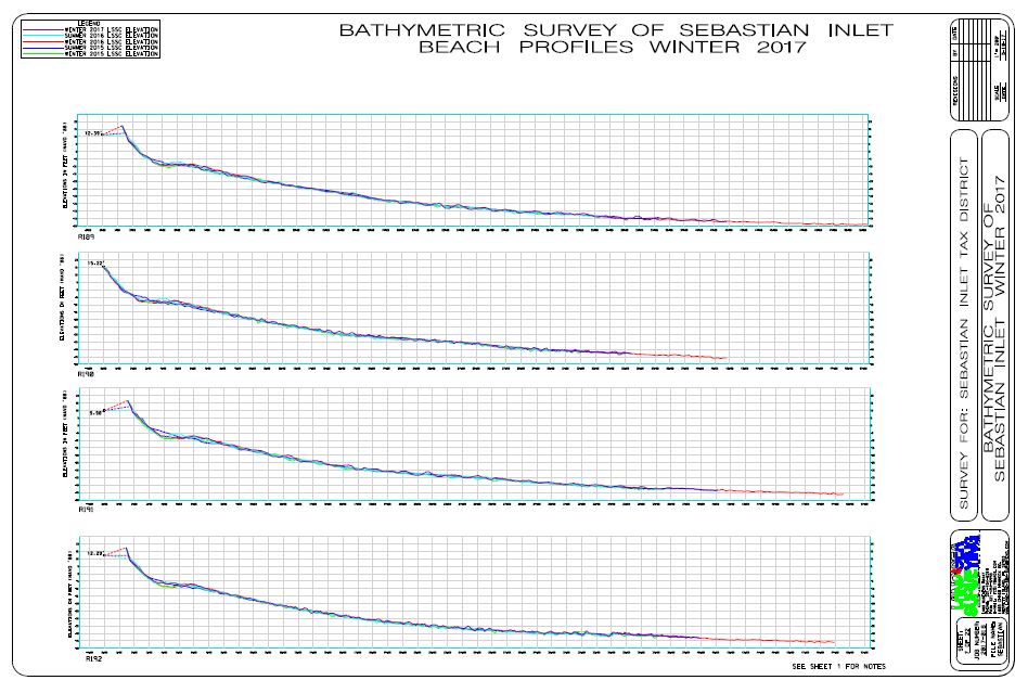
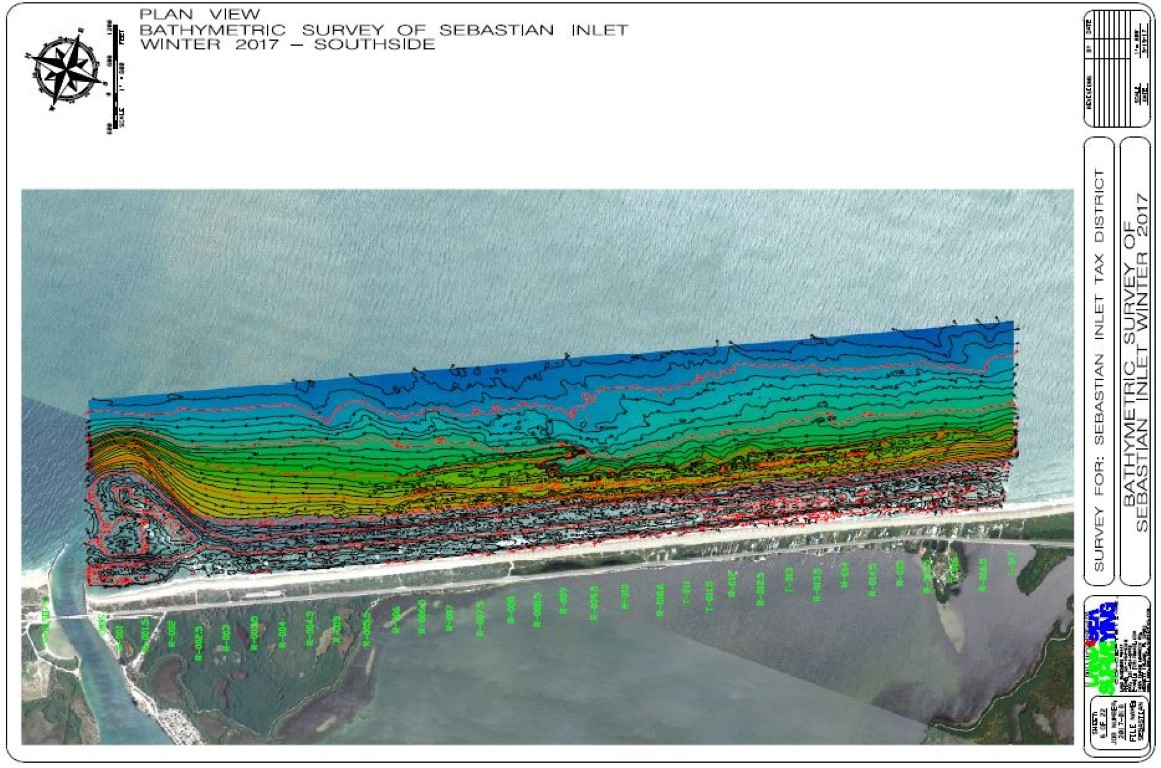
March 2018: Sebastion, Florida
Land & Sea Surveying performed the Winter-Spring Semi Annual Survey of the Sebastian Inlet.
.jpg)
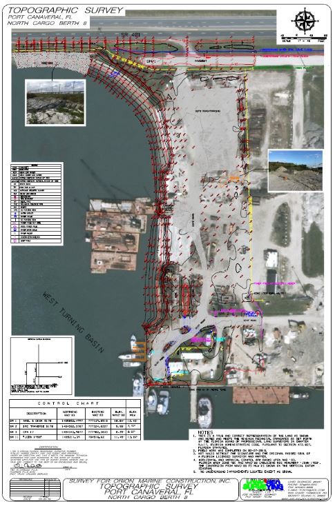
February 2018: Port Canaveral, Florida
Land & Sea Surveying performed a full topographic survey of North Cargo Berth 8 upland at Port Canaveral.
.JPG)
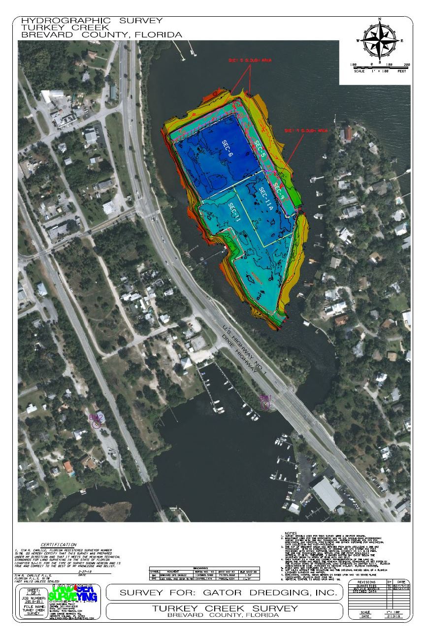
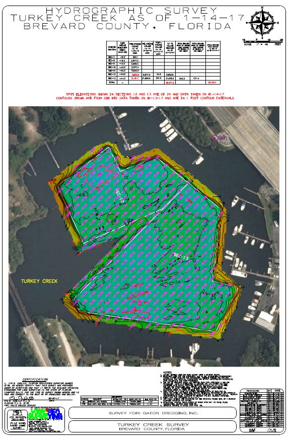
February 2018: Palm Bay, Florida
Land & Sea Surveying performed a Single Beam Hydrographic Survey in Turkey Creek in Palm Bay, Florida for the Post Irma Clean-up Dredge work.
.jpg)
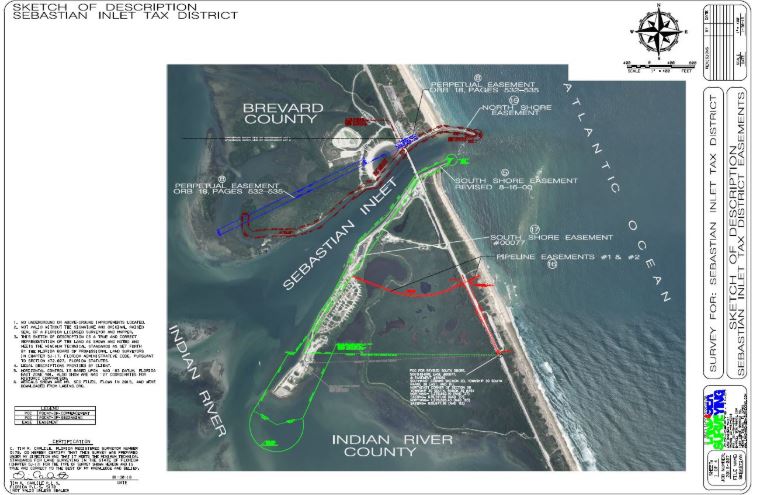
January 2018: Sebastian Inlet, Florida
Land & Sea Surveying calculated 15 easements based on legal descriptions supplied by the District and created Sketch of Descriptions showing all easements with an aerial background to illustrate location of the easement on the ground.
.jpg)
December 2017-March 2018: Kennedy Space Center, Florida
Land & Sea Surveying performed a topographic survey of 66.77 acres of land at Roberts Road out at Kennedy Space Center. RTK GPS and Conventional Total Stations were used for the survey. We also created a boundary and wrote a legal description for the 67 acre parcel.
.jpg)
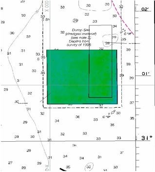
December 2017: Port St. Joe, Florida
Land & Sea Surveying performed a multibeam and magnetometer survey to locate any magnetic anomalies and any visible above ground features in an area located off Port St. Joe, Florida.
Land and Sea performed a multibeam survey utilizing a Reson SeaBat T50-R to locate and measure any above ground anomalies. A total of four exposured were found, and are shown in the images below.
A Geometrics G-882 Marine Magnetometer was used to locate the horizontal position of any magnetic anomalies. Magnetic results can be seen in the image below.
.JPG)
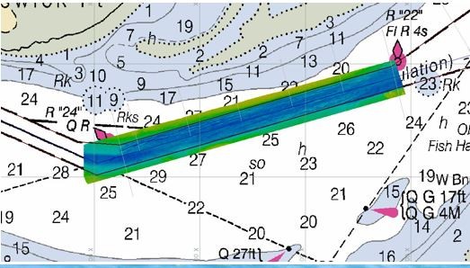
November 2017: Venice, Louisiana
Land & Sea Surveying performed multibeam, magnetometer and side scan surveys to locate a gas pipeline and measure the pipeline exposures off Brenton Sound, Louisiana.
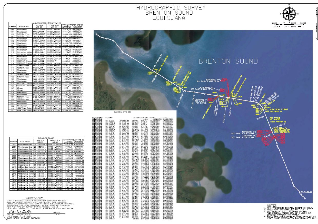
Land & Sea surveying deployed a hazard buoy anchored in relation to the pipeline exposure.
This side scan image shows the exposed pipeline and the mats that covered the pipeline that have been torn away from the pipeline.
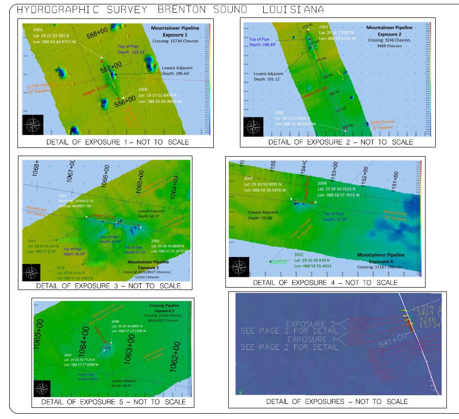
A 3D image of the exposed pipeline.
A Geometrics G-882 Marine Magnetometer was used to confirm the horizontal position of the pipeline.
.jpg)
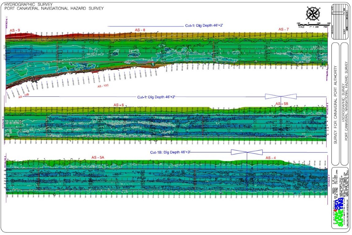
November 2017: Port Canaveral, Florida
Land & Sea Surveying conducted a multibeam survey of an area approximately 3,500 feet west of the collision area. A scour trail was found beginning at sea buoy #3's old location and running west, north and southwest to a possible debris field located at the stern of the AS Fortuna.
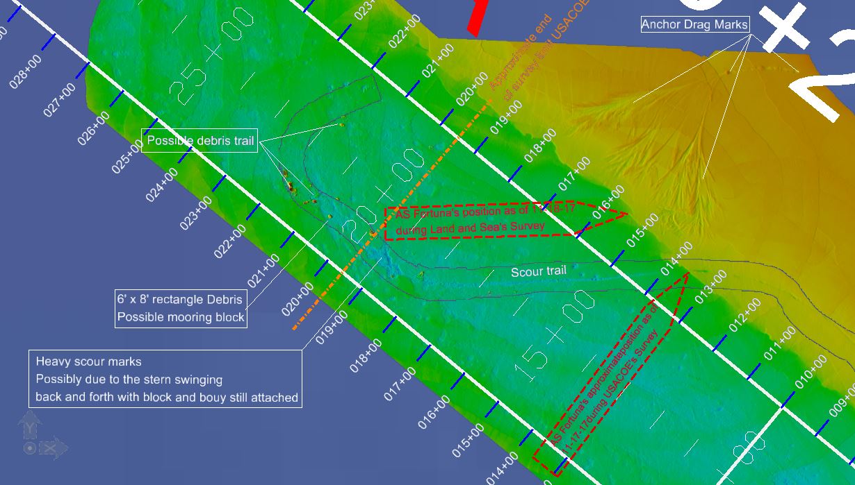
Pictured above are possible debris from the AS Fortuna's collision with sea buoy 3.
The AS Fortuna above left and the new location of buoy 3 above right.
.jpg)
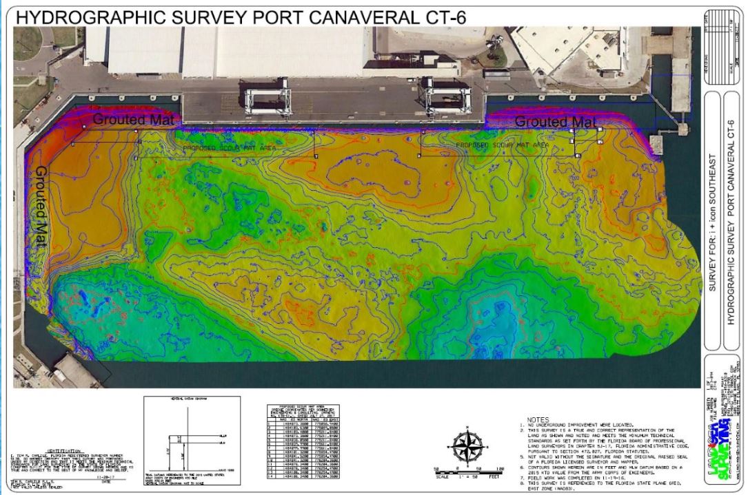
November 2017: Port Canaveral, Florida
Land & Sea Surveying performed a pre-dredge hydrographic survey of Cruise Terminal 6 in support of the Scour and Erosion Repair Project.
.jpg)
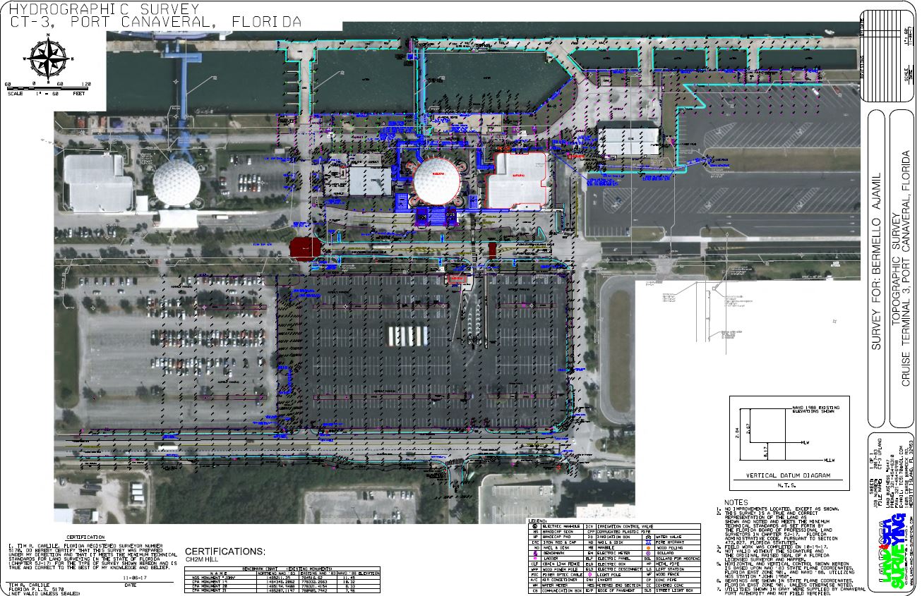
November 2017: Port Canaveral, FL
Land & Sea Surveying performed a pre-demolition survey of Cruise Terminal 3 in support of the proposed reconstruction of Cruise Terminal 3 and the berthing area.
.jpg)
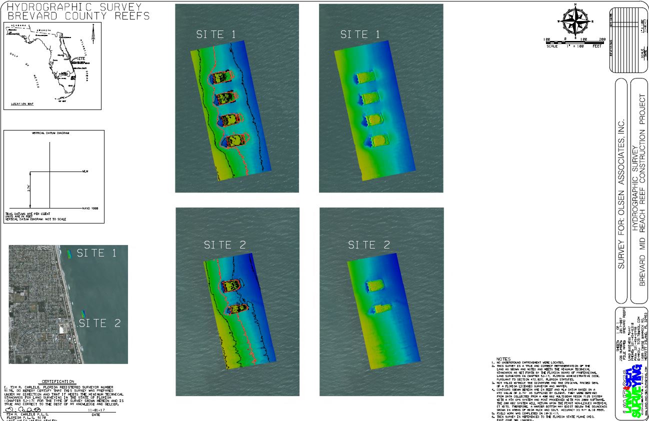
October 2017: Satellite Beach, Florida
Land & Sea Surveying performed a multibeam survey of two artificial reef sites near Satellite Beach, FL to compare pre storm conditions to post storm Irma conditions.
.jpg)
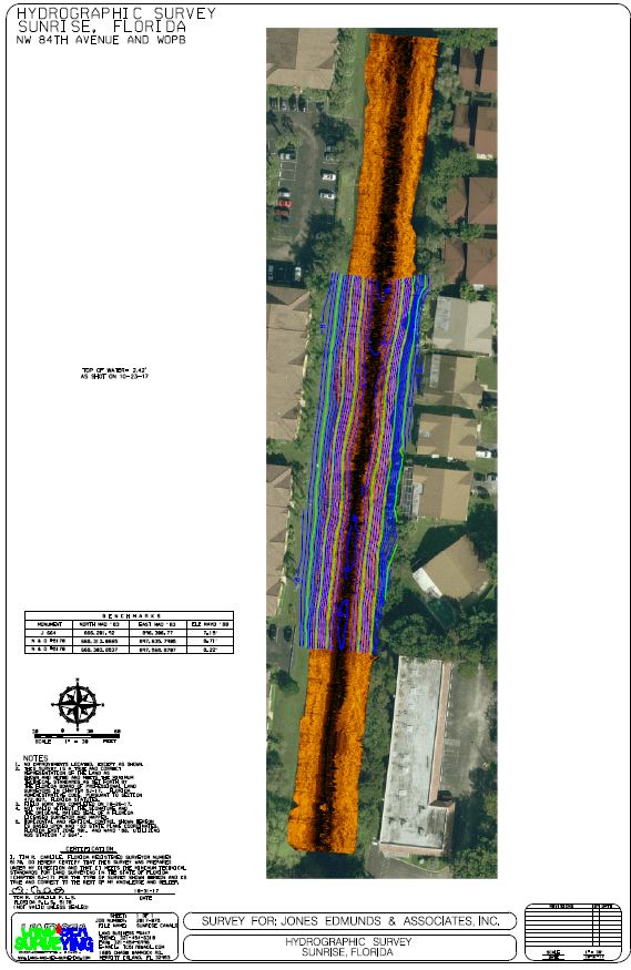
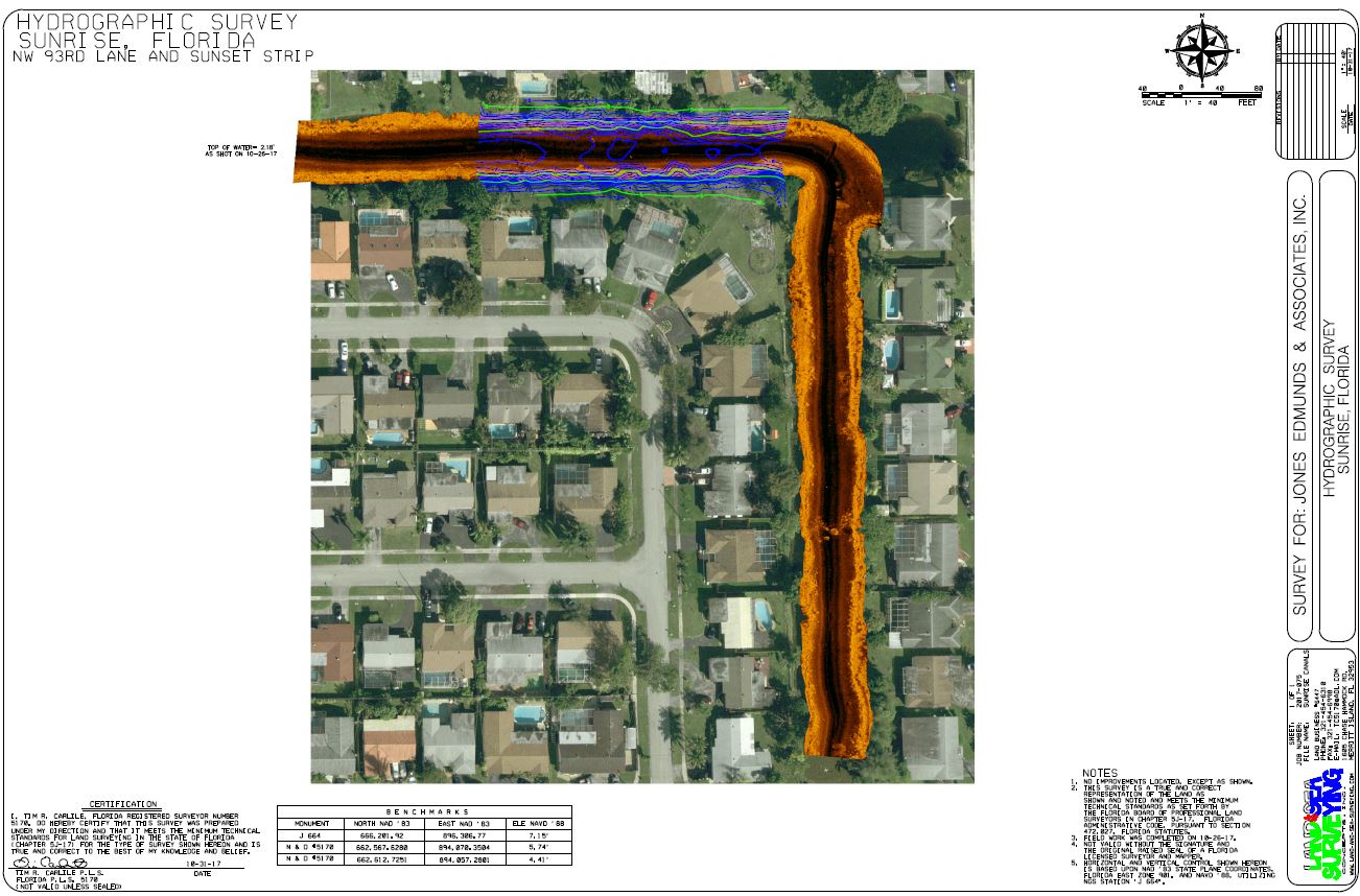
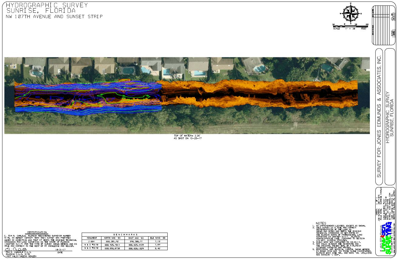
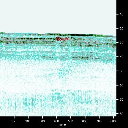
October 2017: Canal Surveys, Sunrise, Florida
Land & Sea Surveying performed hydrographic surveys of six representative canals to investigate the possible undercutting of the banks below water level. The surveys were conducted using single-beam, side scan, and pole shots with an RTK GPS Receiver.
.JPG)
.JPG)
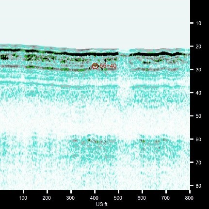
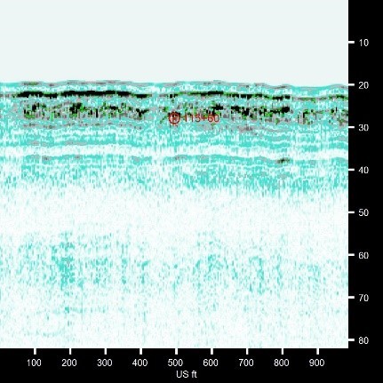
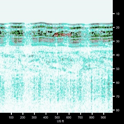
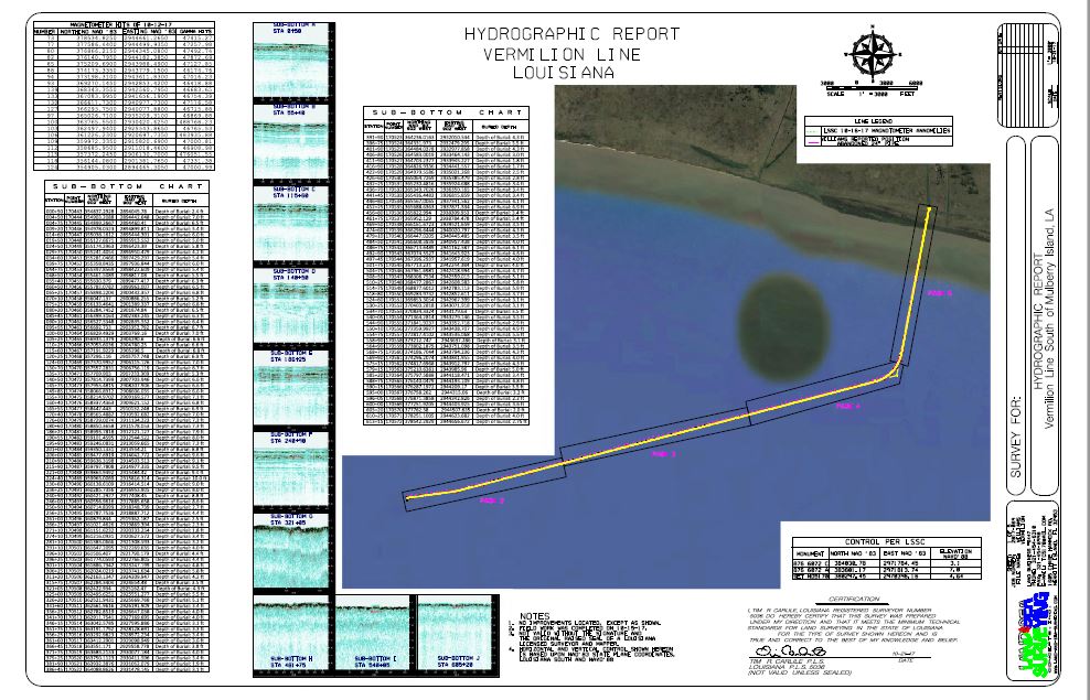
October 2017: Vermilion, Louisiana
Land & Sea Surveying performed multibeam, magnetometer, and sub-bottom profiler surveys to determine the location and depth of cover of a gas pipeline in the Gulf of Mexico.
.jpg)
The images below were captured by using the Edge Tech's SB-216S Full Spectrum Sub-Bottom Profiler.
September 2017: Ft. Pierce, Florida
Land & Sea Surveying performed a topographic survey of Tern Island's storm protection system following Hurricane Irma.
.JPG)
.jpg)
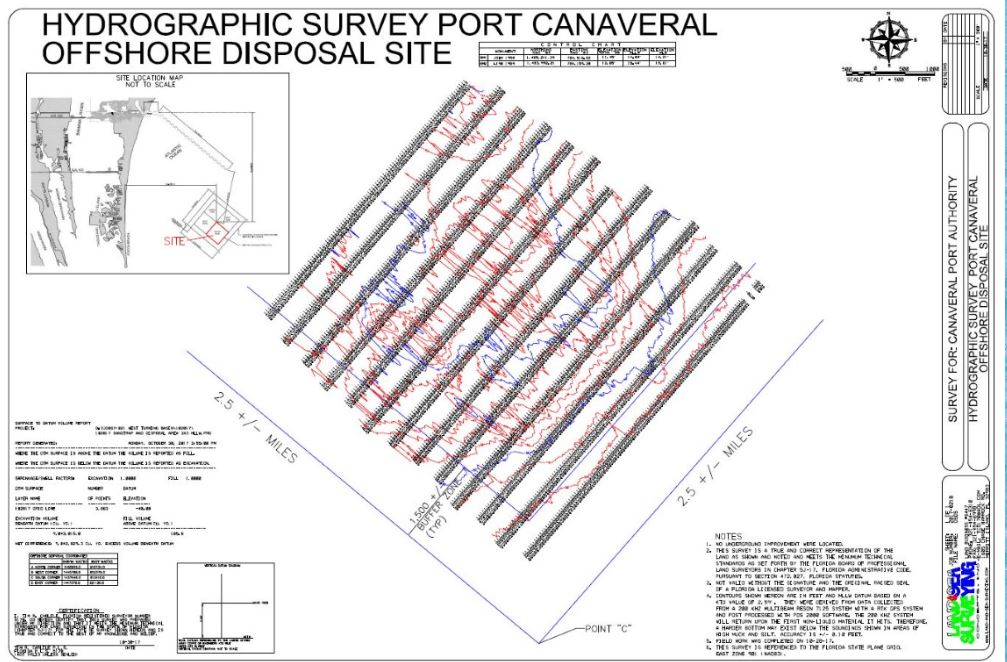
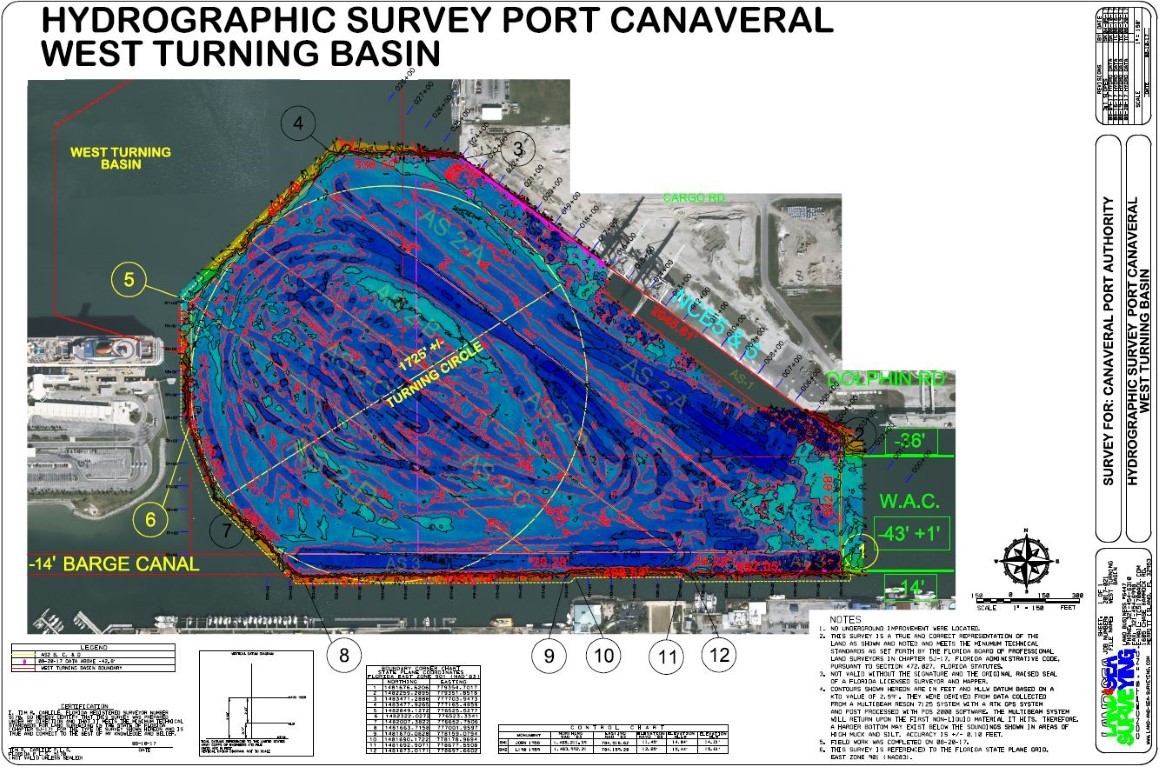
September 2017: Port Canaveral
Land & Sea Surveying provided surveying services to the Canaveral Port Authority to survey the West Turning Basin.
.JPG)
September 2017: Sebastian Inlet Shoreline Rehabilitation
Land & Sea Surveying provided topographic, hydrographic, and side scan surveying services in support of the Post-Hurricane Matthew South Shoreline Rehabilitation project in Sebastian, Florida.

.jpg)
September 2017: Port Canaveral, FL.
Land & Sea Surveying performed a pre-construction bathymetric survey of the berthing area at Port Canaveral's Cruise Terminal 3 for the proposed reconstruction of the cruise terminal.

September 2017: Hurricane Irma Hits Florida
Land & Sea Surveying performed a multibeam survey of the entire port channel to ensure clearance for incoming vessels following Hurricane Irma.
.jpg)
.JPG)
.JPG)
.JPG)

.JPG)
.jpg)
September 2017: Delaware River Pipeline Location Survey
Land & Sea Surveying provided surveying services at Marcus Hook in the Delaware River to locate the position and obtain the depth of cover of a pipeline.
.JPG)
Sub-bottom profiles were collected using the EdgeTech's Full Spectrum Sub-Bottom Profiler to determine the depth of coverage.
A multibeam survey was conducted using a Geometrics G-882 Marine Magnetometer shown just above. A multibeam survey was conducted utilizing a Reson SeaBat T50-R High Resolution multibeam survey system. The system utilizes Teledyne PDS2000 software for collection and processing while at the same time an Applanix POS MV for motion corrections.
.jpg)
August 2017: Port Canaveral, Florida
Land & Sea Surveying provides surveying services to the Canaveral Port Authority to survey a warehouse on the north side of the port.
.JPG)
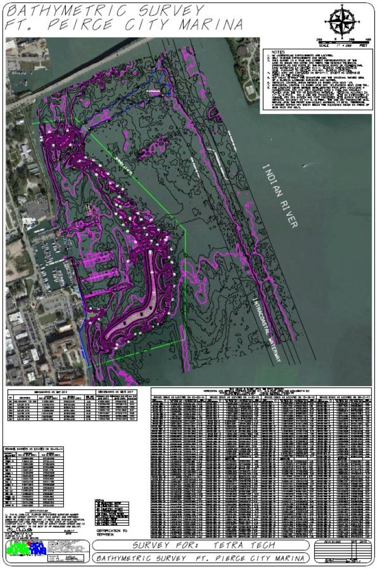
August 2017: Ft. Pierce Marina
Land & Sea Surveying performed the annual hydrographic and topographic surveys at Ft. Pierce Marina to monitor the marina and storm protection islands.
.jpg)
August 2017: Cape Canaveral, Florida
Land & Sea Surveying provided surveying services to BRB Enterprises and the Canaveral Port Authority to survey a tax parcel to establish the boundary line between the parcel and Canaveral Port Authority property.
.JPG)
August 2017: L'Image Villas Townhomes, Titusville, FL.
Land & Sea Surveying provided surveying services for the L'lmage Villas Condos in Titusville. Land & Sea performed Boundary and Partial Topographic Surveys in support of the new dock being constructed at L'lmage Villas Condos.
.JPG)
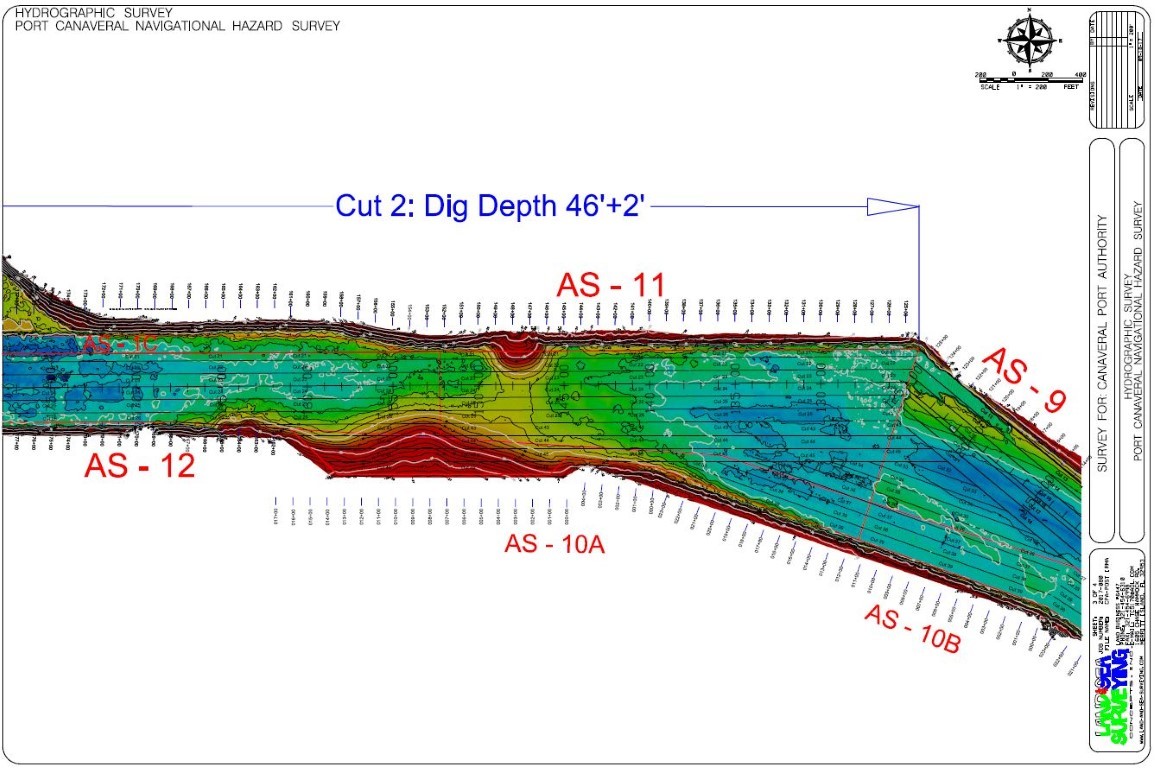
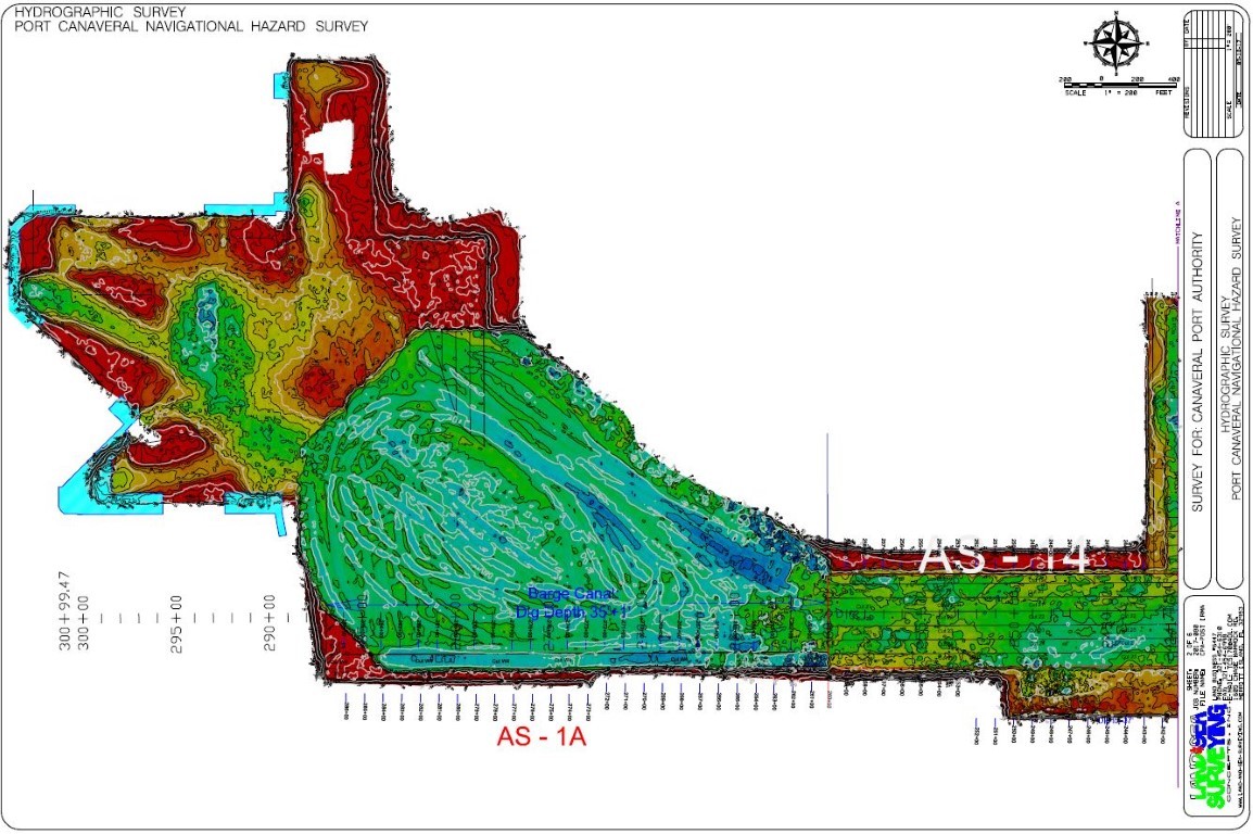
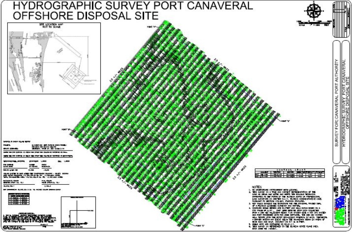
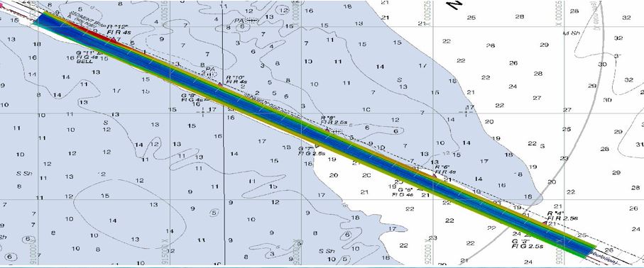
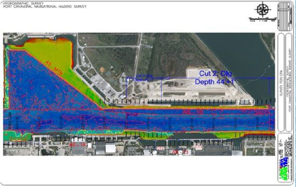
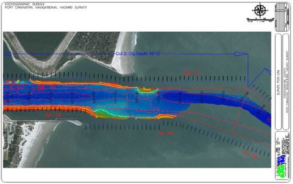
August 2017: Port Canaveral, Florida
Land & Sea Surveying provided surveying services in Port Canaveral in support of the ongoing dredge project to deepen the port channel to -45 ft below the water's surface.
July 2017: Banana River Warning Signs
Land & Sea Surveying provided surveying services to locate warning signs along the Banana River.
.JPG)
July 2017: Tampa Bay, Florida
Land & Sea Surveying provided sub bottom, side scan, and multibeam surveys to determine depth of cover of the existing pipeline, Bartow Lateral in Tampa Bay.
.JPG)
Sub- Bottom Profiles were taken using the EdgeTech's SB-216S Full Spectrum Sub-Bottom Profiler. The EdgeTech SB-216S was chosen due to its strong penetration depth and best resolution imagery possible.
Land & Sea Surveying performed the multibeam survey using a Reson SeaBat T50-R High Resolution multibeam survey system.
June 2017: Windemere, Florida
Land & Sea Surveying provided surveying services in support of the permitting of a channel.
.JPG)
June 16, 2017: Land & Sea Surveying searched for missing ADCPs in Bull Swale.
Area surveyed to find missing ADCPs

In February, Land & Sea Surveying found a culvert while searching for missing ADCPs with the Side Scan Survey. Land & Sea Surveying's most recent survey shows the culvert with Multibeam imaging from a Reson 7125 in -57 feet of water with sub- centimeter accuracies.
Indentations in the sand were discovered 22.39 feet NE of the reported ADCP postition from UF.
Land & Sea Surveying found a target in -57 feet of water about 1365 ft- 160 degrees south of the reported position.
Another target was found 807 feet at 44 degrees NE of reported position in several indentations in the sand in -60 feet of water with an object protruding from the sand.
.jpg)
May 2017: Sebastian, FL
Land & Sea Surveying performed the Winter 2017 semi annual survey of the Sebastian Inlet.
April 18, 2017: NASA
Land & Sea Surveying Performed Structural Support at NASA with Prismless Nikon NPL-322 Total Station
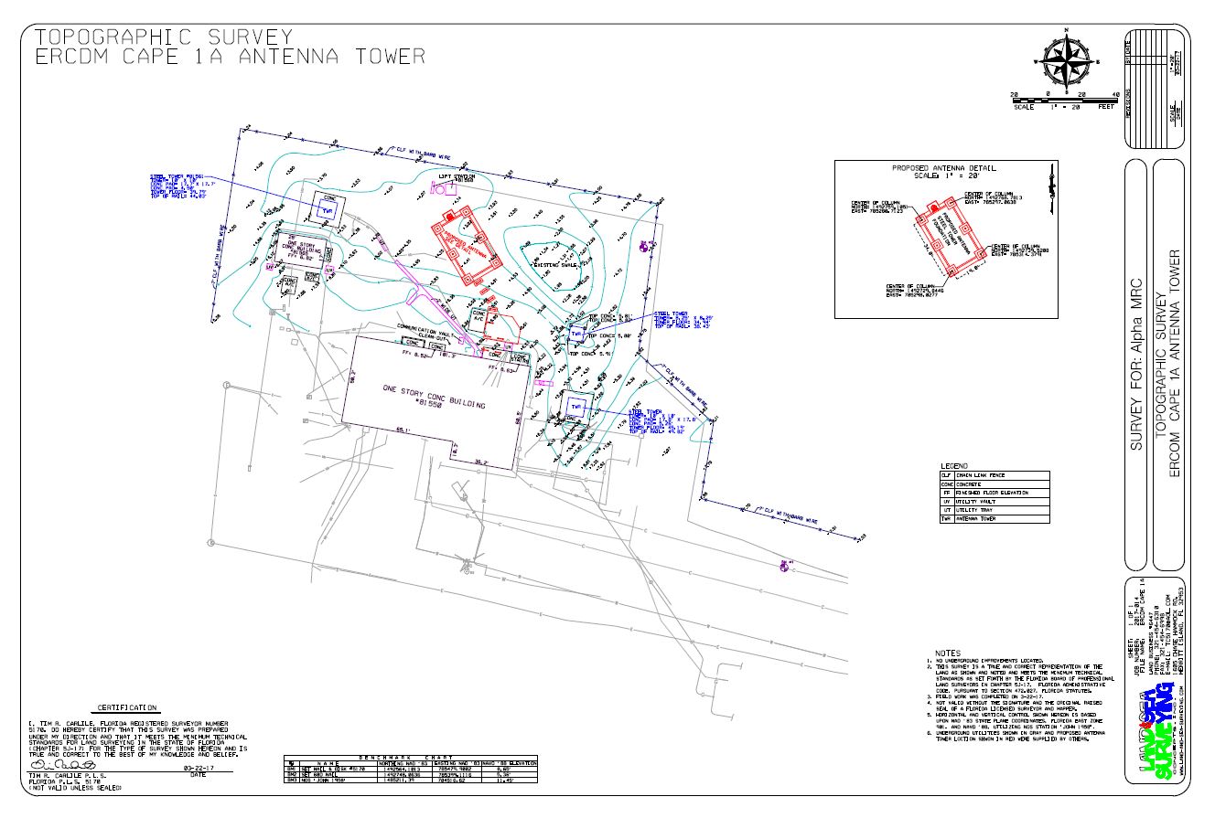
March 2017: Cape Command Facility, CCAFS
Land & Sea Surveying provided topographic surveying services to AlphaMRC in support of the project to replace the antenna tower.
March 2017: Brunswick, Georgia
Land & Sea provided ongoing hydrographic services in support of the dredge project for the port entrance channel in Brunswick, Georgia.
.jpg)
.JPG)
March 2017: Branford, FL
Land and Sea Surveying performed this survey of the Suwannee River in Branford, Florda using the EdgeTech 6205 System.
.JPG)
.jpg)
March 2017: The Intracoastal Waterway, Ormond-by-the-Sea
Land & Sea Surveying provided services to T & T Marine Salvage to assist with the salvage a WWII tug boat. The survey was performed using the Edgetech 6205 System.
Land & Sea Surveying provided hydrographic services for navigational clearance beginning at the Ponce Inlet and surveyed north 20 miles up to Ormond-By-The-Sea.
.jpg)
February 2017: Port Canaveral, FL. Banana River
Land & Sea Surveying provided hydrographic services in support of the shoreline stabilization project located north of the SR-401 bridge.
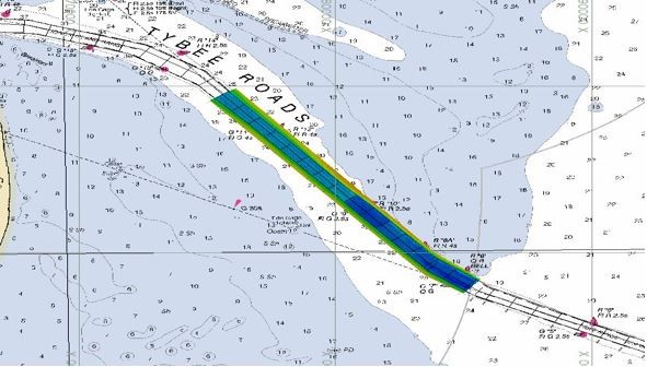
January 2017: Palm Bay, FL.
Turkey Creek
Land & Sea Surveying has provided ongoing hydrographic surveying services in support of the dredging project at Turkey Creek in Palm Bay, Florida.
January 2017: Pensacola, FL.
Gas Main Location - Pensacola Bay Bridge
Land & Sea Surveying provided services to locate a submerged 8-inch steel gas main along the Bay Bridge from Gulf Breeze to Pensacola.
December 2016: Savannah, GA.
Savannah Entrance Channel
Land & Sea Surveying performs multi-beam and single-beam hydrographic surveying in support of the dredging at Savannah Entrance Channel.
Land & Sea Surveying completed a hydrographic survey of the entrance channel, approximately 16,000 feet, and the ODMDS, approximately 4,200 by 9,500 feet, using either single-beam or multi-beam methods.
.JPG)
.jpg)
October 2016: Panama City, FL. Coast Guard Station Hydrographic Survey
.JPG)
Land & Sea Surveying performed a hydrographic survey, a side scan sonar survey, and a magnetometer survey to determine the existence and extent of any obstructions in the berth area. The survey area is the length of the wharf, approximately 800 feet and extends out into Alligator Bayou (a minimum of 50 feet offset any shore side structures). Approximate survey area is shown outlined in yellow on the image below. Land & Sea Surveying also collected bathymetric data within the survey area using a 200 kHz single beam transducer with RTK GPS for horizontal and vertical positioning.
.JPG)
.jpg)
October 7, 2016: Hurricane Matthew Strikes the East Coast of Florida.
Hurricane Matthew wreaked havoc on Port Canaveral's restaurants, marinas, and many other buildings.
Many boats and barges were subjected to Hurricane Matthew's path of destruction as shown below.
"The Beast" (in the pictures below) remained safe and unharmed. Land & Sea Surveying's team was in Port Canaveral only a few hours after Hurricane Matthew ravaged the port.
The Land & Sea Surveying team inspected Port Canaveral using the multibeam system to ascertain if there was any debris on the channel floor.
.JPG)
.JPG)
Once the Land & Sea Surveying Team determined that the port channel was clear of debris, they gave navigational clearance to the cruise and cargo ships waiting to enter the port.
.jpg)
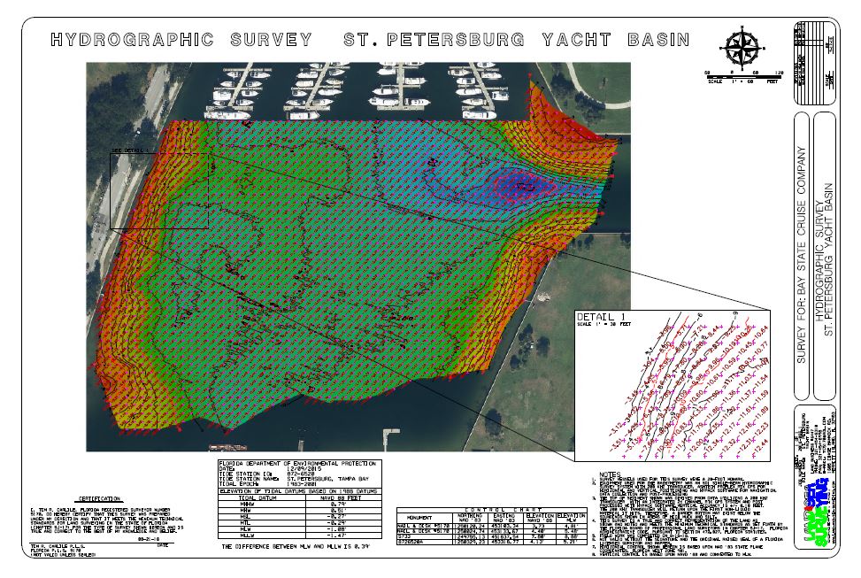
September 2016: Hydrographic Survey of St. Petersburg, FL Yacht Basin
Land & Sea Surveying performed a single beam hydrographic survey of the north yacht basin at St. Petersburg Municipal Pier to verify sufficient depth for incoming vessels.